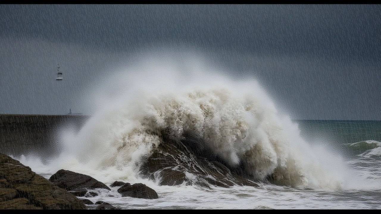
Heavy rain is sweeping across England this weekend, with the Met Office issuing multiple Yellow National Severe Weather Warnings for flooding, travel chaos, and strong winds — a pattern that’s expected to drag on into early next week. The warnings, active from Friday night, November 28, 2025, through Tuesday, December 2, 2025, are not just routine alerts. They’re a sign that the UK is caught in a relentless Atlantic weather machine, and communities from Dartmoor to Kent are bracing for impacts that could last days.
Three Waves of Rain, One Unsettled Pattern
The Met Office has laid out three distinct pulses of heavy rainfall. The first hit Friday night, November 28, with bands of rain sweeping from southwest England toward the North Sea by Saturday evening. Then came the real punch: a second wave rolling in Sunday night, November 30, spreading across southern England by Monday morning, December 1. And just when people thought it was easing, a third band moved in across central and southeast England — lingering into Tuesday morning.
Accumulations vary wildly by terrain. While most areas will see 20–30 mm, places like Dartmoor and Exmoor could get 60–80 mm — nearly three inches of rain in under 24 hours. The North Downs and South Downs aren’t far behind, with 50–60 mm possible. That’s not just a soggy day — it’s a flood risk. Roads could wash out. Drainage systems are already saturated from earlier rains. And with gusts hitting 40 mph in eastern counties, debris and fallen trees are a real threat.
Who’s Affected — And How Bad Is It?
The warning zone stretches from the coastlines of Bournemouth Christchurch and Poole and Dorset to the urban sprawl of London and Kent. Eleven local authorities in the South East — including Brighton and Hove, Hampshire, and West Sussex — are under alert. Three in the South West are too: Wiltshire, Bournemouth Christchurch and Poole, and Dorset.
It’s not just rural areas at risk. London’s underground network, already strained by aging infrastructure, could face delays. The Met Office warned that “travel disruption is likely,” and local councils have begun sandbagging key flood-prone zones. In Exeter, where the Met Office is headquartered, riverside neighborhoods are on high alert. One resident, Sarah Telford, told a local news outlet: “We’ve had three flood warnings in the last six months. This one feels different — the wind’s howling, and the sky’s just dumping it.”
Why This Is Happening — And Why It Won’t Stop Soon
Behind the rain is a slow-moving Atlantic low-pressure system, the kind meteorologists call a “blocking pattern.” These aren’t rare, but they’re becoming more frequent. The Met Office confirmed in its long-range forecast that “successive areas of low pressure” are moving in from the west, often stalling near the UK. That means showers, not just storms — and prolonged wet spells.
Temperatures are hovering near average — around 9°C — but the real danger is the combination of rain and wind. Gusts up to 50 mph in coastal areas can turn small branches into projectiles and knock out power lines. In East Sussex, emergency crews reported 12 minor power outages by Saturday afternoon. “It’s not the volume of rain alone,” said Dr. Alan Mercer, a climatologist at the University of Reading. “It’s the timing. We’re hitting ground that’s already waterlogged. That’s when runoff becomes flash flooding.”

What Comes Next — And What You Should Do
By Tuesday, December 2, conditions should begin to improve. The Met Office forecasts “sunny spells and blustery showers,” with temperatures holding steady. But don’t breathe easy yet. The agency’s long-range outlook warns of “changeable and often unsettled conditions” through mid-December. That means more low-pressure systems are already forming over the Atlantic — likely to arrive by midweek.
For now, the advice is simple: avoid non-essential travel, especially near rivers and coastal roads. Check local council websites for flood alerts. If you live in a basement flat or near a stream, consider moving valuables upstairs. And keep a battery-powered radio handy — power cuts are possible.
Historical Context: Is This Normal?
The Met Office, established in 1854, has recorded increasingly frequent severe rainfall events since the 1990s. The winter of 2013–14 saw 14 consecutive days of rain across southern England. In 2020, Yorkshire broke its single-day rainfall record. This weekend’s event doesn’t yet match those extremes — but it fits the trend.
What’s different now is speed. Climate models suggest Atlantic storms are moving slower, lingering longer over the UK. That means more water falling in fewer hours — and less time for the land to absorb it. “We’re not just getting more rain,” said Professor Helen Williams of the UK Climate Impacts Programme. “We’re getting it in bursts that overwhelm our systems.”
Frequently Asked Questions
How much rain is expected in total over the weekend?
Most areas will see 20–30 mm of rain, but high ground like Dartmoor and Exmoor could receive 60–80 mm — equivalent to nearly a month’s average rainfall in just 48 hours. The heaviest totals are expected between Saturday and Monday, with rainfall peaking overnight on Sunday into Monday.
Which areas are at highest risk of flooding?
Low-lying areas near rivers in Dorset, Wiltshire, and East Sussex are most vulnerable. Urban areas like Portsmouth and Southampton face drainage system overload. The Met Office has flagged 17 specific flood risk zones in its public alert map.
Why are the warnings called ‘Yellow’ and not ‘Amber’ or ‘Red’?
Yellow warnings mean ‘be aware’ — potential for disruption, but not life-threatening conditions. Amber means ‘take action,’ and Red means ‘danger to life.’ While impacts are serious, the Met Office hasn’t upgraded because rainfall totals, though high, are still below historical thresholds for Amber. However, localized flooding could still be severe.
Is this linked to climate change?
Yes. Warmer Atlantic waters are fueling more intense storms, and slower-moving systems are holding rain over the UK longer. The Met Office’s own climate reports show a 15% increase in heavy rainfall events since 1961. This weekend’s pattern is consistent with projections for the 2030s — meaning we’re seeing the future arrive sooner than expected.
Will public transport be affected?
Absolutely. Southern Rail, Great Western Railway, and Southeastern services have already announced potential delays due to track flooding and landslides. London Underground stations near the Thames, including Waterloo and London Bridge, are monitoring water levels. Commuters should check National Rail Enquiries for real-time updates.
When will the weather finally clear up?
Tuesday, December 2, should bring drier conditions with sunny spells and scattered showers. But the Met Office warns that another Atlantic low is forming — possibly arriving by Thursday. The next week remains highly unsettled. Don’t expect a full return to calm until mid-December.